NEWS
Project will tell the story of how I-496 construction impacted Lansing's black community.
Vickki Dozier
Lansing State Journal

A 1904 Oldsmobile carrying Barbara Dean, Miss Michigan Highways of 1970, and driven by Bernie LaDuke, with an unidentified man and Dick Letts, far right, at the opening of the I-496 Oldsmobile Expressway, Dec. 18, 1970.
Courtesy Photo/Historical Society Of Greater Lansing
The Washington Avenue bridge takes shape in June 1967, one of several bridges to span the expressway that runs below ground level for some distance.
Lansing State Journal File Photo
A home at Main and Logan streets is crushed in 1966 as part of the connector route clearance for Interstate 496.
Lansing State Journal File Photo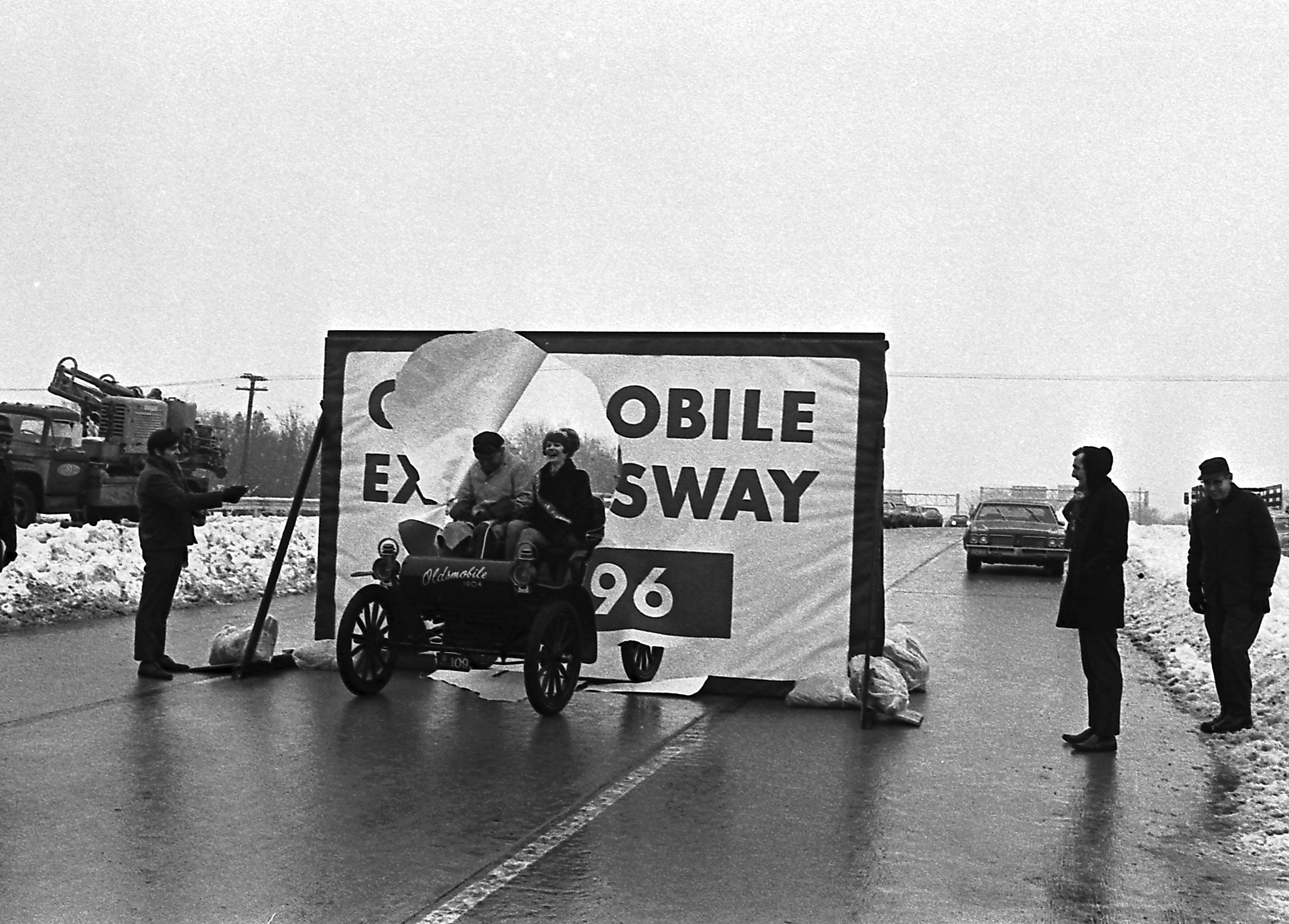
On Dec. 18, 1970, the new freeway, called the Oldsmobile Expressway, opened. It eased traffic flow in Lansing but cut through the heart of the city's largest black neighborhood, displacing many families.
Lansing State Journal File Photo
On Dec. 18, 1970, the new freeway, called the Oldsmobile Expressway, opened. It eased traffic flow in Lansing but cut through the heart of the city's largest black neighborhood, displacing many families.
Lansing State Journal File Photo
A flier dated June 9, 1965, from a scrapbook donated to the "Paving the Way" research and documentation project on the impact of I-496 on the black community.
Courtesy Photo/Historical Society Of Greater Lansing
Construction of the Cedar Street exit ramp for Interstate 496, shown on Dec. 28, 1967.
Lansing State Journal File Photo
A bulldozer demolishes a home as part of the connector route clearance for I-496, January 1966.
Lansing State Journal Lansing State Journal File Photofile Photo, Lansing State Journal File Photo
A bulldozer demolishes a home as part of the connector route clearance for I-496, January 1966.
Lansing State Journal File Photo
A bulldozer demolishes a home as part of the connector route clearance for I-496, January 1966.
Lansing State Journal File Photo
A bulldozer demolishes a home as part of the connector route clearance for I-496, January 1966.
Lansing State Journal File Photo
A historical photograph from the 1960s of the I-496 corridor.
Lansing State Journal File Photo
A historical photograph from the 1960s of the I-496 corridor.
Lansing State Journal File Photo
A historical photograph from the 1960s of the I-496 corridor.
Lansing State Journal File Photo
A historical photograph from the 1960s of the I-496 corridor.
Lansing State Journal File Photo
A historical photograph from the 1960s of the I-496 corridor.
Lansing State Journal File Photo
A historical photograph from the 1960s of the I-496 corridor.
Lansing State Journal File Photo
A historical photograph from the 1960s of the I-496 corridor.
Lansing State Journal File Photo
A historical photograph from the 1960s of the I-496 corridor.
Lansing State Journal File Photo
A historical photograph from the 1960s of the I-496 corridor.
Lansing State Journal File Photo
A historical photograph from the 1960s of the I-496 corridor.
Lansing State Journal File Photo
Jessie Richardson, left, with grandson Tyrone Gridiron (3), in front of their home on St. Joseph and Everett. The photo was taken after the demolishing in 1965-1966 of more than 600 homes in the area. Photo was taken just prior to the beginning of construction. Across the median the Main Street School can be seen.
Courtesy Photo/Adolph Burton
A residence at 700-704 Pine St., taken in 1962. The home is one that was demolished for the construction of 1-496.
Courtesy Photo/Capital Area District Libraries
A house at 700 Townsend, taken in 1939. The home is one that was demolished for the construction of 1-496.
Courtesy Photo/Capital Area District Libraries
A house at 701 Birch, taken in 1950. The home is one that was demolished for the construction of 1-496.
Courtesy Photo/Capital Area District Libraries
A business at 701 Division. It is one of many that was demolished for the construction of 1-496.
Courtesy Photo/Capital Area District Libraries
A house at 704 Townsend St., circa 1941. The home is one that was demolished for the construction of 1-496.
Courtesy Photo/Capital Area District Libraries
A house at 708 Butler, circa 1938. The home is one that was demolished for the construction of 1-496.
Courtesy Photo/Capital Area District Libraries
A historical photograph from the 1960s of the I-496 corridor.
Lansing State Journal File Photo
A house at 708 Chestnut, circa 1938. The home is one that was demolished for the construction of 1-496.
Courtesy Photo/Capital Area District Libraries
A house at 709 Chestnut, taken in 1956. The home is one that was demolished for the construction of 1-496.
Courtesy Photo/Capital Area District Libraries
A house at 709 Middle, taken in 1953. The home is one that was demolished for the construction of 1-496.
Courtesy Photo/Capital Area District Libraries
A house at 709 Pine St., taken in 1948. The home is one that was demolished for the construction of 1-496.
Courtesy Photo/Capital Area District Libraries
Residences at 710-712 Division, date unknown. The residences were demolished for the construction of 1-496.
Courtesy Photo/Capital Area District Libraries
A home at 711 Townsend St., taken in 1962. The home is one that was demolished for the construction of 1-496.
Courtesy Photo/Capital Area District Libraries
A home at 713 Butler St., taken in 1963. The home is one that was demolished for the construction of 1-496.
Courtesy Photo/Capital Area District Libraries
A house at 715 Butler St., taken in 1938. The home is one that was demolished for the construction of 1-496.
Courtesy Photo/Capital Area District Libraries
Residences at 716-718 Birch, taken in 1955. The home is one that was demolished for the construction of 1-496.
Courtesy Photo/Capital Area District Libraries
House at 717 Birch, taken in 1951. The home is one that was demolished for the construction of 1-496.
Courtesy Photo/Capital Area District Libraries
A house at 717 Middle, taken in 1955. The home is one that was demolished for the construction of 1-496.
Courtesy Photo/Capital Area District Libraries
A house at 720 Chestnut. The home is one that was demolished for the construction of 1-496.
Courtesy Photo/Capital Area District Libraries
A historical photograph from the 1960s of the I-496 corridor.
Lansing State Journal File Photo
A historical photograph from the 1960s of the I-496 corridor.
Lansing State Journal File Photo
Aerial view of construction on I-496 in the 1960s.
Courtesy Photo/Historical Society Of Greater Lansing
Aerial view of construction on I-496 in the 1960s.
Courtesy Photo/Historical Society Of Greater Lansing
Aerial view, April 26, 1970, shows area around Logan/MLK, the GM plant, and I-496 under construction.
Courtesy Photo/ Lansing City Assessor/Stereo-Foto, Inc., Aerial Photographs, Lansing And Environs, Capital Area District Libraries.
Churches on W. St. Joseph Street near S. Logan/MLK, circa 1972. Shown are (L to R) Mount Calvary Church, 1112 W. St. Joseph; Lansing Church of God in Christ, 1100 W. St. Joseph (NW corner with Logan); Galilee Baptist Church, 1026 W. St. Joseph. Interstate 496 had only been open for a short time when this was taken.
Courtesy Photo/. Local History Photograph Collection, Capital Area District Libraries.